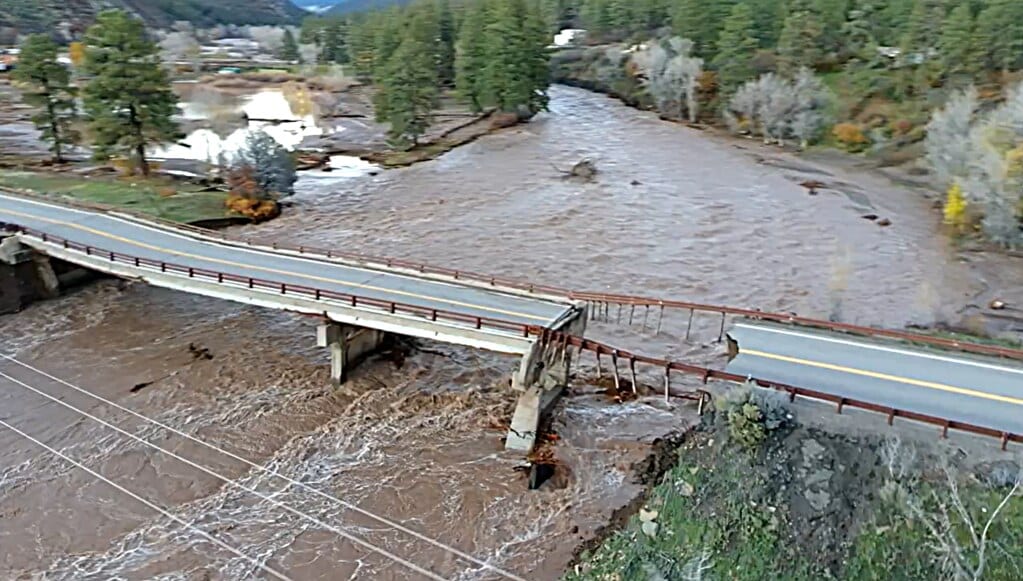
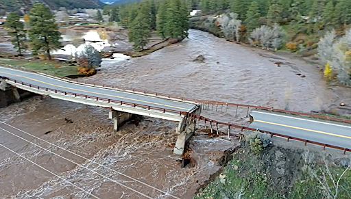
Recent flooding washed out roads and a bridge, causing full closures on common routes and significant repair delays along key corridors.
The Colorado Department of Transportation urges motorists and commercial motor vehicle drivers to prepare for extensive detours when accessing Southwest Colorado, specifically Pagosa Springs and nearby Durango. Recent flooding washed out roads and a bridge, causing full closures on common routes and significant repair delays along key corridors.
Motorists should avoid downtown Pagosa Springs unless they are local residents or emergency personnel, as several municipal streets remain flooded. For information on the Southwest Colorado flood response and recovery can be found at media.codot.gov.
Currently, CDOT is prioritizing US 84 south of Pagosa Springs and focusing efforts to keep this highway open. Two areas along this highway are undergoing repairs and stabilization. Travelers will encounter flagging personnel or temporary light signals guiding traffic. Motorists are urged to slow down and drive with extreme caution.
Extended regional highway closures as of Thursday, Nov. 5
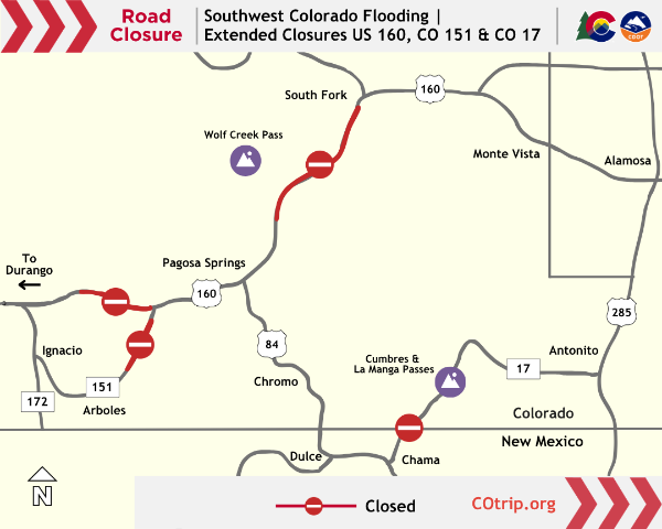
Dozens of emergency closures have occurred across the region over the past two weeks. As of Thursday morning, Nov. 5, several major closures remain in place from prior flood events. Highway conditions update continuously on COtrip.org and the COtrip Planner app.
Note: COtrip does not report local closures within the city, county or forest road systems. For local road closures, please contact the relevant city or county road department.
- CO 151 south of Chimney Rock(MP 27 to 30) - CO 151 sustained additional roadway damage within an active emergency reconstruction zone. Floodwaters washed out another section of the roadway on Nov. 1, approximately four miles south of the US 160 junction. Contractors are on-site to continue reconstruction and repair the new damage.
- US 160 Pagosa Springs to Durango(MP 121) - Multiple sections along this 30-mile corridor between Pagosa Springs and Durango require roadway maintenance or emergency repairs, notably at the Piedra River Bridge, located 18 miles west of Pagosa Springs. Following the collapse of its support piers, the bridge requires a complete rebuild; crews will install a temporary structure as soon as site conditions permit.
- US 160 Wolf Creek Pass(MP 157 to 184.5) - Wolf Creek Pass remains closed from east of Pagosa Springs to South Fork. At least four locations along this 33-mile stretch have sustained severe damage caused by flooding, mud and rock slides. High water along the South Fork of the Rio Grande undercut the shoulder and travel lanes and washed out a segment of roadway, approximately Six miles west of South Fork, through The Narrows.
- CO 17 Antonito to New Mexico state line(MP 0 to 39) - CO 17 is anticipated to open by the end of today, Nov. 5 to restricted access only. No thru-traffic is allowed. Drive with caution through the area, as repair work continues at several locations along Cumbres and La Manga Passes. Motorists cannot travel past the New Mexico state line due to significant damage to NM State Highway 17 and ongoing NMDOT repairs.
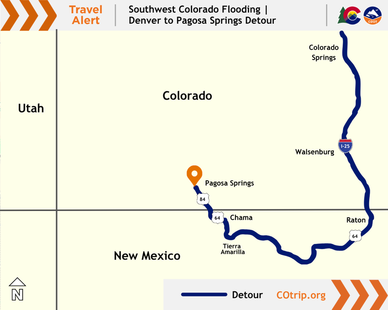
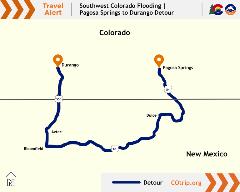
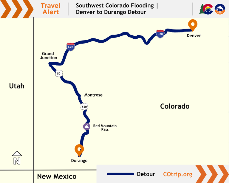
Southwest Colorado detours
From Denver to Pagosa Springs (travel time, just over eight hours)
- I-25 south into New Mexico
- At Raton, take US 64 west to Tierra Amarilla
- At Tierra Amarilla take US 84/64 north to Chama
- At Chama take US 84/64 north, into Colorado and Pagosa Springs
Essential travel from Pagosa Springs to Durango (travel time, around two and a half hours).
- US 84 south into New Mexico
- Turn right onto US 64 west to Dulce
- At Dulce continue west on US 64 to Bloomfield
- At Bloomfield turn right or onto US 550 north to Aztec
- Continue north on US 550 into Colorado and Durango
From Denver to Durango (travel time, just over eight hours)
- I-70 west to Grand Junction
- US 50 south to Montrose
- US 550 south to Durango (freight drivers should to consider the westerly alternate route via CO 145 through Telluride)
Surrounding state road conditions
Check real-time Colorado travel conditions at COtrip.org or on the COtrip Planner mobile app. For conditions in neighboring states, visit:
- New Mexico: NMroads.com
- Arizona: AZ511.gov
- Utah: udottraffic.utah.gov
Guidance for freight and commercial drivers
With repair crews actively working along the river corridors, long-haul freight operations will save considerable time and avoid bottlenecks by routing around the region:
- Use alternate interstate corridors: Interstate freight moving east–west across Colorado or northern New Mexico should avoid rural mountain passes and route via I-70 to the north or I-40 to the south.
- Stick to state-designated routes: Commercial drivers making essential deliveries into the area must avoid GPS shortcuts onto unpaved, seasonal forest roads or rural county roads. Many backroads cannot support heavy vehicle turning radiuses, have strict weight limits or have sustained minor shoulder damage. These roads may have also sustained flooding damage. View the latest travel impacts, road repairs and open corridors on COtrip.org or through the free COtrip Planner app.
- Build in extra transit time: Deliveries routed into Pagosa Springs, Bayfield or Durango should account for substantial extra travel time.
Tips for essential travelers
Crews will continue cleanup and roadway stabilization throughout the week to restore normal travel patterns as quickly as possible. For those who must travel locally:
- Know before you go: View the latest travel impacts, road repairs and open corridors on COtrip.org or through the free COtrip Planner app.
- Slow down in work zones: Maintenance and bridge inspection crews are working closely alongside active roadways. Please yield extra space and obey posted speed reductions.
- Keep supplies on hand: As with any mountain travel, maintain a full tank of fuel and keep extra snacks, water and warm layers in your vehicle in case of travel delays.
Know Before You Go
Travelers are urged to “know before you go.” Gather information about weather forecasts and anticipated travel impacts and current road conditions prior to hitting the road. CDOT resources include:
- Road conditions and travel information: COtrip.org
- Download the COtrip Planner app: bit.ly/COtripapp
- Sign up for project or travel alerts: bit.ly/COnewsalerts
- Check scheduled construction lane closures: bit.ly/laneclosures
- Connect with @ColoradoDOT on social media: X, Facebook, Instagram and YouTube
Download the COtrip App!
The new free COtrip Planner mobile app was designed to meet the growing trend of information on mobile and tablet devices for the traveling public. The COtrip Planner app provides statewide, real-time traffic information, and works on mobile devices that operate on the iOS and Android platforms. Visit the Google Play Store (Android devices) or the Apple Store (iOS devices) to download!
 2026 Mid-term Election results
 Gov. to Visit Flood-Stricken San Juan County
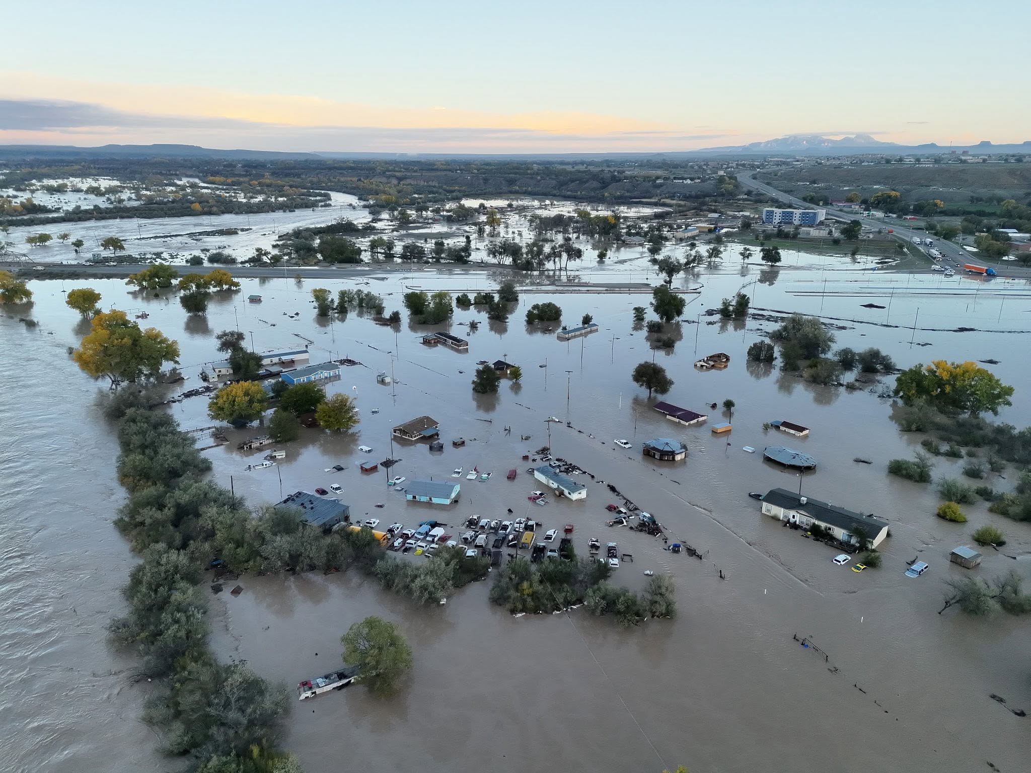 National Guard, State Police carry out rescues as historic flooding hits San Juan County
 Bloomfield: Wastewater Emergency
 Kirtland Students on Remote Learning thru Thursday
 Woman's Husband Arrested for Kirtland Killing